The park office is at the entrance, and visitors are required to stop and fill out a use permit. Only a certain number of permits are allotted per day, but I can't imagine that number ever being reached. The yellow carbon copy goes in a box at the station when you enter; the important lines are the time you expect to return and the trail on which you'll start. The white copy stays with you while you're out and goes in an adjacent box when you make it back. A ranger in pajama pants (I didn't know about this career option) was advising a couple with Missouri plates on where to camp and how to get there. The young woman looked thoroughly out of her element. She was asking something about how to get their gear to the campsite and seemed to be under the impression they could drive to it. Nothing about her demeanor said, "Tonight I'm going to dig a hole in the woods and poop in it." I hope she knew about that particular feature of the backcountry campsites because I can't describe her face for a sketch artist if they find his body.
With a trace of rain falling, I started on the Rocky Point trail. It's rocky and pointy. With steep switchbacks around rugged, lichen-covered boulders immersed in fresh lime green foliage, it's also the antithesis of what people who've never been to Oklahoma believe Oklahoma to be.


Rocky Point dumps you onto the Little Bugaboo trail. Little Bugaboo fords and then loosely follows Little Bugaboo Creek. Last year the waterfalls there were the highlight of the trip, but this time the creek was reduced to a trickle between sluggish, pollen-filmed puddles.

At least four Oklahoma towns host rattlesnake roundups in the month of April. While all of those towns are on the other side of I-35, McGee Creek still falls squarely in the range and preferred habitat of the timber rattlesnake, western pygmy rattlesnake, and copperhead. Western diamondbacks and cottonmouths also aren't out of the question. The trail map I'd picked up at the office advised carrying a snakebite kit, advice I was obeying exactly as well as the advice to not hike alone. Considering all that and the disappointing state of the creek, I skipped the scramble down the rocks to the waterfalls.

From that point onward, the trails lead directly away from the park office into the wilderness. Little Bugaboo ends at an intersection with South Rim. Literature about the trail system says that South Rim and some of the other more distant trails were once "Jeep roads." An ancient truck fender that serves as a landmark proves that someone, sometime, did indeed drive out there. In the past the road must have been better maintained--or maybe it wasn't and that's why there's a chunk of a truck.
I went on into territory I hadn't seen on the last trip. The North Rim trail bends back westward on the far side of the valley. Robert Frost took the road less traveled once; if he'd done it a dozen times, he might have stumbled onto North Rim. In terms of absolute distance to civilization, it's actually not so remote--less than ten miles east is the Indian Nation Turnpike, and it's still just a few easy miles back to the park office. But except for the trail itself, traces of human existence are extremely scant. So far the only people I'd seen along the trail were at a campsite near the end of Little Bugaboo. I like solitude. North Rim was a lot of it even for me. With increasing isolation came uneasiness at the number and magnitude of things that could go wrong, realistic or not. (Remember the part about the snakes?)


It was almost time to turn around when I came to the head of the Wildcat Canyon trail. "Wildcat Canyon" sounded so much more thrilling than "Little Bugaboo" or "South Rim" or "North Rim" that I just had to see what it was about. There were no wildcats and no canyon, and I'm not sure what I thought I was going to do if I encountered either.


Hiking out was an adventure, especially after passing the end of last year's trek. Hiking back was an exhausting slog with an eye on the clock, a long drive looming, and a very rumbly stomach. A phone app would later estimate that the round trip took 2290 Calories, which is a whole lot more granola bars than I'd stuffed in my little gym bag. Lots of people run this distance without stopping. I have no idea how or why.

Spotting a better overlook than the marked one off South Rim, I ventured out onto it for a moment. An "overlook" at McGee Creek is a place to peek through some nearby trees at some other trees farther away. A couple of guys hacking noisily through the woods down below made for human contact #2 in some eight miles of walking.


Back at the parking lot my boots, which were not at all green before, were caked with a lifetime supply of sneezes.

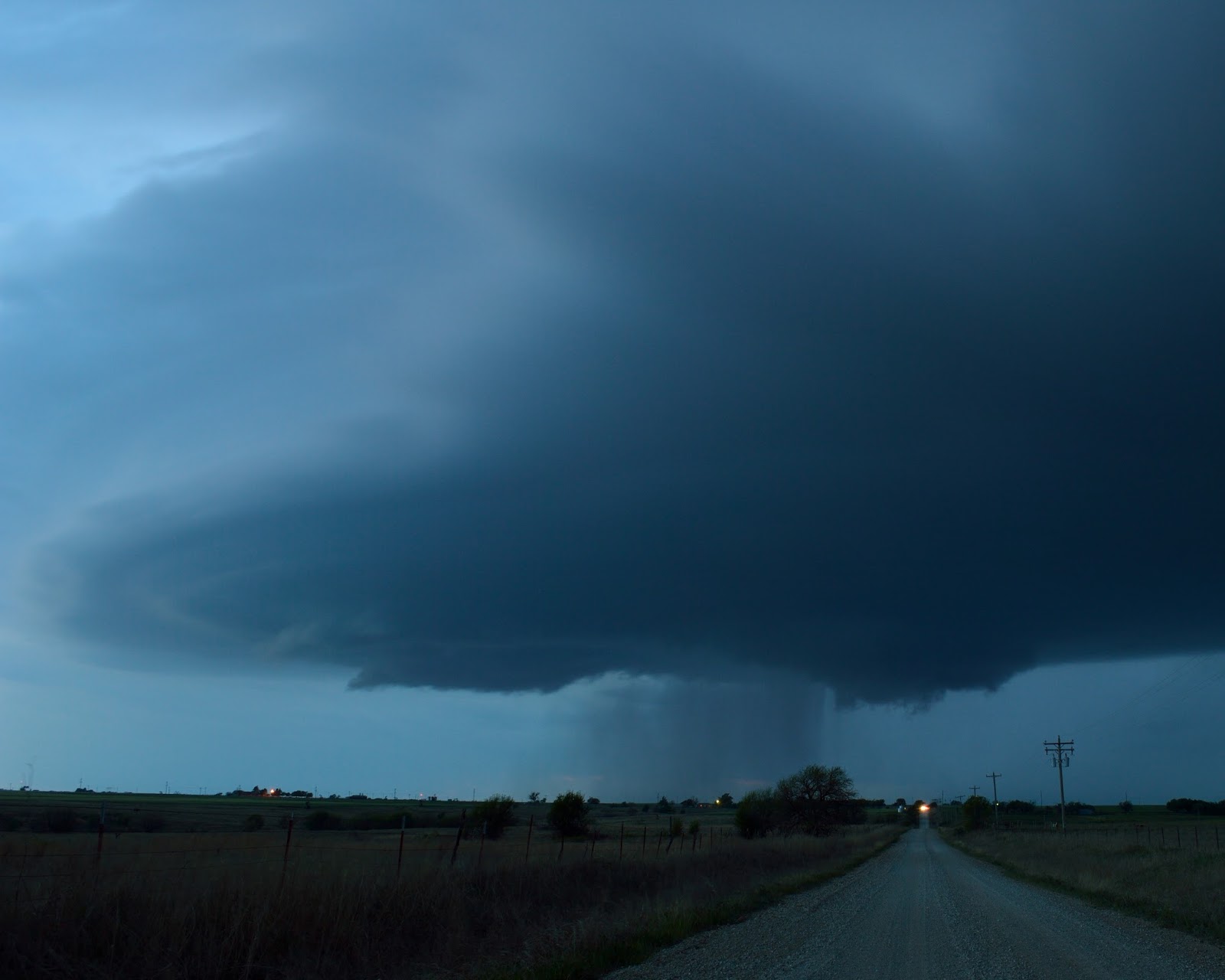
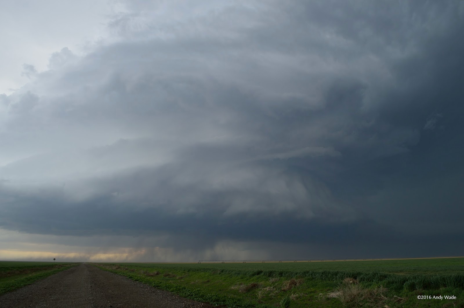
I was happy to have seen twelve miles and change of brilliant springtime Oklahoma, pollen and all. But spring scenery around here is not limited to ground level. The next day was a Sunday, and with modest storms ongoing in southwestern Oklahoma, I left Norman after church in the evening. It was a race against the setting sun to a supercell that had separated itself from messy convection and was passing north of Walters. I approached along the forward flank with daylight left and inflow streaming in overhead. The storm was somewhat high-based and deep laminar layers at the base of the updraft, though visually attractive, suggested stabilization with nocturnal cooling. Other chasers farther south had much better views of the stacked-plates structure. The view from the east was all I could get with darkness falling, and it wasn't bad.