Friday, April 17, 2015

16 April 2015 Panhandle chase

I got a late start out of Norman at noon.  Usually that would be okay for a chase in the central and eastern Texas Panhandle, but a fairly deep layer of backed low-level winds meant (a) no EML and (b) upslope up the Caprock.  Storms were well underway when I got off I-40 around Groom and started edging westward toward an intense area of convection near Panhandle.  It looked like it might propagate ahead of the outflow boundary lying just east of most of the ongoing storms.  Before long there was a persistent dust whirl to the southwest where a developing mesocyclone should have been.  I wasn't comfortable calling it a tornado on the visual appearance alone, but its position relative to the storm and Twitter reports from closer chasers suggested it was a weak tornado.


The road network and terrain just east of Amarillo were outstanding for chasing during this storm's early life.  I hung back east of the storm as it struggled to clear the outflow boundary laid down by extensive mid-afternoon convection.


Multiple small areas of tight rotation came and went as the storm overtook the boundary.  One was visually striking, with wisps of cloud curling into it.


After further failed attempts and several convincing tornado lookalikes, low-level rotation became focused just north of the dirt road I'd been following eastward for miles.  That road was ending and I was going to have to take my south escape (Hwy 70) to I-40.  Had the storm waited another few minutes, I would have been gone, but it produced a small dusty tornado not far to my northwest.


A line of gustnadoes appeared along the gust front to the south and southwest.


Through roads to the east suddenly disappeared, leaving I-40 (well south of the storm) as the only option for repositioning.  Meanwhile, the supercell took on an HP mode.


The next stop was FM 291.  I didn't venture far northward on it, only far enough to get a view of the mammatus to the north and some typical HP structure.  Velocity signatures were only growing more impressive on what was now the dominant storm, but there was no point trying to intercept tornadoes so completely wrapped in rain and hail.


Then it was back east on I-40 to Hwy 273 and northward to W Road.


I took dirt roads eastward to FM 1443.  Again I pushed north to see all I could see of the inflow/updraft area; there were some lowerings, but surging rain and hail forced me to bail southward quickly.


I gained some space by going east as far as Shamrock and coming up Route 83 in front of the storm, which was still showing strong rotation.  A hill just west of the intersection of 83 and FM 1906 offered the only good viewing south of Wheeler.  Despite very impressive velocity signatures (and at one point even a correlation coefficient minimum suggestive of lofted debris) immediately to the west, nothing definitive could be made out in the precip.  The bear's cage was visually obvious as the entire east side of the storm rotated around it; how much of it was actually tornado is anybody's guess.


I navigated eastward and northward on back roads, barely making it through a low spot where rain had fallen from a nearby storm, and saw a brief funnel near Kelton on Hwy 152.


That should have been the end of the chase day, but after a pit stop in Sayre back on the Oklahoma side, two circulations moving toward Cheyenne were too strong and too close to ignore.  I did a bit of spotting by lightning on Route 283 south of town.  Each mesocyclone had a wall cloud or lowering associated with it, but surface temperatures were just a little too cool for tornadoes at this point.


12 hours and 45 minutes on the road, a small tornado or possibly two, and one beast of a supercell.  In yet another slow tornado year, today was a good day.

Update:  NWS Amarillo's survey determined the tornado east-northeast of Groom was, not surprisingly, an EF-0 with winds around 70 mph.  Estimated path length was 2.4 miles and estimated width was 30 yards (quite a bit smaller than the initial dust circulation in the photos).  This is a good example of a tornado that probably would never have been recorded two or three decades ago--weak, short-lived, only visible at fairly close range, and occurring in a desolate area.

Friday, June 20, 2014

19 June 2014 lightning show

   The 15th International Conference on Atmospheric Electricity is taking place in Norman this week.  There is also actual lightning.  I left Norman Thursday evening after helping out with the conference and met an ongoing cluster of strong to marginally severe thunderstorms near Binger, OK.  The easternmost cell began propagating slowly eastward, developing a couple transient areas of low-level rotation and producing quite a bit of CG lightning.  I set up just off Route 81 south of El Reno as the sun finally dropped far enough to allow lightning shots.  Outflow winds sustained at 40+ mph made it nearly impossible to keep the camera steady on the tripod.


At least one flash connected with the ground between me and the horizon:


I missed quite a few close CGs.  The storms slowly began to slide east and with several flashes reaching ground less than a mile away, it was time to reposition east down Reno.


   I dropped south and east into Mustang, then headed for the hill on Highway 9 west of Norman.  The storms had almost stalled again and were too far away.  After some maneuvering around Blanchard, I gave up and made for the OU parking garage.  There wasn't much to the storms at that point, but a small cell to the west fought off nocturnal cooling long enough to spit out several more CGs.


Tuesday, May 27, 2014

Three tornadic supercells in West Texas, 5/26/14

   Monday (Memorial Day) was an epic chase of about 600 miles round-trip.  It was also my mom's first storm chase.  We left Arlington just after 1 p.m. and raced toward supercells developing in West Texas, from Midland/Odessa northward.  We closed on the first storm, a tornado-warned supercell turning southeastward near Big Spring, a little after 5 p.m.  It was an aquamarine-glowing beast of a storm that was becoming HP as precip fell between it and a new supercell to its west-southwest.


County Road 262/371 just south of I-20


Intersection of County Roads 371 and 270, 5:33 p.m.

   The storm exhibited a more defined base as it approached I-20.  At 5:38 p.m., a spotter reported a rain-wrapped tornado crossing I-20 near Coahoma.  The tornado was not clearly visible from our location nearly 10 miles to the east.

Rain-free base at 5:35 p.m.


5:38 p.m.


As the gust front hit, we retreated to FM 670 to escape southward, stopping for a few last shots of the blue-green storm.  It wouldn't regain serious tornado potential but was photogenic.


   With the first storm weakening and cutting off northward and eastward road options, we targeted the new supercell behind it, which was diving southeastward toward Sterling City.  In Sterling City, we watched storm #2 attempt to get its act together.  A few minutes after the following photo was taken,  a tornado was reported 14 miles to the west-southwest.  The new updraft trying to get going on the southern flank was interesting, but never seemed particularly organized, so any tornado was probably in the rain-obscured lowering farther north.  Scud from the edge of the precip core was continuously being pulled up into that region of rain wrap, looking like a tornado I saw on 4/17/13 near (coincidentally) Sterling, OK.


West side of Sterling City, 5:40 p.m.

   While in Sterling City, I was approached by a local resident in an SUV who introduced herself as the editor of the newspaper.  She asked what was coming and when I told her the storm was tornado-warned, she asked why the sirens weren't sounding.  That was a good question.  In fact, even as the storm closed in, I never heard a siren in Sterling City.  After that, another local hollered out of her car window and warned us not to go west.  "There's five tornaduhs in there!"  Even in the age of Twitter, real-time severe weather information remains a game of telephone; an iffy multi-vortex report becomes five tornadoes.  We dropped south of town on Highway 163 and the logjam commenced.  Chasers, Skywarn spotters, tour buses, locals with kids in tow--you name it.  Everybody in Sterling County, Texas seemed to be on 163.

   A bizarre low-level feature appeared as the storm came closer.  It didn't even seem to be attached to the cloud base and was displaced from the main updraft, but was slowly rotating and ascending.  At times it became elongated and extended to the horizon.


Just south of Sterling City looking west, 7:08 p.m.

   About that time, the first hailstone either of us noticed came flying into my mom's hand.  The storm was chucking at least half dollars ahead of it; they were actually being blown from east to west in the inflow.  Not wanting to take damage just to watch a weird little gustnado, we bailed southward as hailstones shattered across the road and occasionally on the car.  Fighting hail, traffic, and rolling terrain, we didn't get a good look at the storm as it crossed Highway 163 and had to watch it from farther south.


Looking north around the time a rope tornado was reported, 7:14 p.m.

   Well clear of the storm's path, I took a couple of photos at 7:24 p.m. that show a thin, faint feature extending from the cloud base to the horizon north of the RFD gust front.  I hardly noticed it at the time, but after seeing SPC tornado reports at 7:13, 7:15, and 7:31, I went ahead and emailed the photos to NWS San Angelo in case they had additional information.


~20-30 miles south of Sterling City looking north-northwest, 7:24 p.m.


Tighter crop of tornado-like feature


Second photo of the same feature, taken about 10 seconds later

   The second storm moved off to the east and we edged north on Highway 163 to intercept a third supercell trailing behind it.  Stopping just north of a Texas Tech research radar, we watched an incredibly long inflow tail slide into the new storm's well-developed mesocyclone.  A tornado was reported, probably with this storm, at 8:05 p.m., but no tornado was evident from our position.


Looking west from Highway 163, 7:58 p.m.


8:00 p.m.


8:02 p.m.


8:03 p.m.


8:05 p.m.


8:07 p.m.

   This supercell swept across 163 with no sign of producing a tornado, and we ended our chase.  More storms continued to fire near Midland and train behind those we'd intercepted, though, making it impossible to reach I-20 without a chance of getting cored.  Even to attempt it would have required reliable radar data, something we lacked given the sparse cell service.  Instead, we raced supercell #2 to San Angelo in hopes of circling around it.  We took desolate 163 southward to FM 2469, which cut eastward through remote oil fields to a gritty little wide spot in the road called Mertzon.  From there population density slowly increased as we followed Route 67 northeastward into San Angelo.  Lightning flashed continuously in the slowly weakening supercell to our north.  We left San Angelo on 67 just before the storm moved in and dropped low-end severe hail all over town.  New convection grew overtop of us near Ballinger, filling the gaps in a spectacularly electrified MCS.  From there it was north to Abilene and east on I-20 to DFW, most of the way in trailing stratiform precip that seemed to have a lot of tiny hail in it.

   We were close to multiple tornado reports from multiple storms and saw nothing conclusive.  Cell towers and paved roads were few and far between.  The storms were messy, threw large hail well outside their cores, and rarely sustained strong low-level mesocyclones for more than a few minutes.  For as many reports as there were, there have hardly been any tornado photos making the rounds.  Some have expressed doubt about one particular report of a multi-vortex tornado early in the second supercell's life.  Even with a clear target area, it was actually a challenging day to chase.  Still, it's hard to complain about three tornadic supercells in open country.  With Oklahoma sitting at 6 tornadoes on the year--#6 hardly counts, a landspout under cold-core convection on 5/27--this is as good as it gets right now.

Thursday, May 8, 2014

5/7/14 Gracemont, OK severe thunderstorm

   After dark Wednesday night, I went after developing storms in west-central Oklahoma in hopes of catching some lightning.  There was nearly continuous lightning as I closed on a storm near Binger and dropped south in front of it, but it was all in-cloud and not especially photogenic.  I got a few shots of a shelf cloud near Gracemont, my only photo stop of the night, and chased the storm back to Newcastle as it kept fighting to stay surface-based and wrap up short-lived mesocyclones.  The only excitement was some unexpected hail in RFD southwest of Tuttle.

   As I learned the next day, Gracemont took some serious straight-line wind damage about 20-25 minutes after I left it.  These photos are from a little more than a mile south of town, looking north along U.S. 281, at 10 p.m.


Tuesday, April 29, 2014

Cars, tornadoes, and bad decisions: 2014 edition

   A "storm chaser"--I use the term very loosely, as he seems more like a local attempting suicide--came within a football field or two of getting himself killed in the 4/28/14 Tupelo, MS tornado.  This in itself is not good.  What's ten times worse is posting a dramatic video to Youtube and encouraging other people to follow suit:


Let me be the first of pretty much everyone in the meteorological community to say:
  • This guy is incredibly lucky and incredibly stupid.
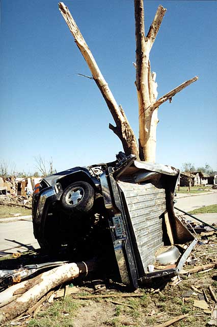
  • At no point was he "in the tornado."  If what he experienced looks scary, realize that he was only getting inflow jets and possibly the outermost fringe of the circulation.  Had he been fully inside the tornado, he would probably have encountered winds twice as strong.  He and a crumpled wad of metal sort of resembling his car would have been found out in that field, if not in two different fields. This, or worse, is what happens to vehicles directly impacted by strong tornadoes:
(photo from NSSL)
  • Vehicles are still not safe in tornadoes!  El Reno proved that point, when several died on the roads and none died in structures.  The Arkansas tornado that threw cars off I-40 the day before this storm proved that point again.  Drivers will keep becoming examples until we learn this.  Thousands of people have been pulled alive from homes and businesses directly hit by violent tornadoes in the past few years.  I don't know of very many who survived direct hits in cars, except the fortunate TWC team in their huge SUV.
   As hard as it is to say, I don't think this guy did quite everything wrong.  He could have made one worse mistake by driving straight into the tornado.  Stopping and letting it pass always beats racing it to a crossing point (ask Mike Bettes).  The idea is to stop away from the tornado, not as close as possible to certain death.

Friday, April 25, 2014

4/26-27/14 severe weather

   Flow associated with a developing surface low in the High Plains in advance of an upper trough ejecting from the Southwest will result in rapid low-level moisture advection into the Southern and Central Plains on Saturday.  Dewpoints in the low to mid 60s will result in considerable instability (2000-3000 J/kg CAPE), but a stout cap will remain in place through most of the day as the upper-level forcing to weaken it will lag to the west.  Convergence and convective mixing along the dryline will be nearly enough to overcome the cap as stronger flow aloft/differential vorticity advection finally arrives in the evening.  Models differ on timing and location of convective initiation, but the most likely scenario is a storm or two in southwestern Oklahoma or western North Texas just around sunset.  Large low-level hodographs and increasing deep-layer shear will support supercells capable of producing very large hail.  LCLs will initially be too high for an appreciable tornado threat.  However, as the boundary layer cools and moistens with loss of diurnal heating, cloud bases may lower.  Model consensus is that a ~50 kt low-level jet will emerge over northwestern Texas and western/central Oklahoma in this time frame.  Extreme low-level vertical shear combined with any cloud cover that results from distant anvils/synoptic lift/moist advection in the LLJ should prevent rapid stabilization of the boundary layer in the 00-04z period.  Remaining instability up to 2000 J/kg CAPE and large values of SRH owing to the LLJ would mean a risk of a few tornadoes, possibly significant, if mature surface-based convection continues beyond sunset.  The temporal window for tornadoes will be short.  The most likely area for this tornado threat, if it materializes, would be southwestern to west-central Oklahoma.  Given modest storm motion, storms do not appear likely to reach the OKC metro before boundary layer decoupling ends tornado chances for the night.

   Sunday's primary severe weather setup will be to the east of I-35 after the dryline surges through in the morning hours, with southeastern Oklahoma into the Arklatex seeing the highest risk.  Current trends in the NAM suggest against ruling out morning convection in the I-35 corridor, though, and will need to be monitored.

Thursday, April 24, 2014

4/23/14 lightning show

   After an awards ceremony for the College of Atmospheric and Geographic Sciences, I headed southwest to just east of Chickasha to catch the one surviving thunderstorm from the evening's low-end severe event out west.  There were quite a few CGs over Chickasha, but activity dropped off a little once I headed back to Norman and met up with a dozen or so met students on the OU parking garage roof.